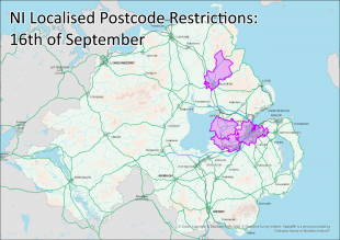
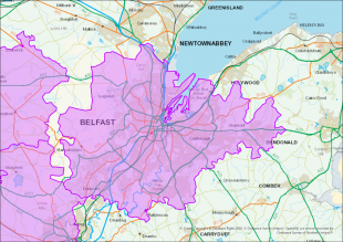
Ordnance Survey Northern Ireland (OSNI) were tasked by the Department of Health to identify all postcodes within COVID-19 restricted areas for the creation of new legislative regulations for Northern Ireland. Localised restrictions were being brought in as a response to increased cases of the virus in certain postcodes areas. The Department also wanted to communicate this information to the public so OSNI staff suggested creating an interactive map for the public to view the newly enforced COVID-19 restricted areas. The Department of Health stipulated that these postcode areas may be added and removed from the local restrictions as patterns of infection change, therefore, any mapping solution needed to be adaptable.
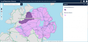
The OSNI NIMA Support team devised postcode polygons based on the location of individual addresses as derived from the OSNI Pointer Address product, and from this isolated the areas due to be restricted. This data was then passed over to the OSNI Spatial NI team, who created a web map, comprising of the restricted areas, the OSNI Fusion Basemap and a search widget hosting OSNI address data (Pointer), to allow the public to search for their own address or postcode in order to see if they fell into one of the new restricted areas. This effective visual tool ensured that the localised restrictions were clearly communicated to the public in a user-friendly manner. The web map is fully adaptable and updated as restrictions change, sometimes within a very short timeframe. It has proven to be an extremely popular application with over 54,000 views in the first three days of its launch.
The map has been hosted on the NI government’s website, NI Direct, for all to use: https://apps.spatialni.gov.uk/RestrictionExtentsApp/
Leave a comment