The Thames Region Flood and Coastal Committee (RFCC) have called for more Natural Flood Management (NFM) to promote adaptation to climate change. NFM aims to protect homes and businesses from flooding and benefit important habitats and wildlife. By emulating natural processes that slow runoff, improve attenuation, permeability and evaporation, NFM can increase the landscape’s natural capacity to reduce flooding while improving water quality and ecological diversity. Individual NFM features store relatively small amounts of water, however at a catchment scale, networked NFM features have a cumulative effect that alters the flow within and out of a catchment.
The Thames RFCC commissioned the creation of a map to inform catchment-wide investment planning in NFM. Funding is currently distributed to local NFM projects without regional oversight. A regional NFM priority map is required to ensure that funding goes where the NFM will be most beneficial. As local authorities need assistance in prospecting for NFM sites we are also producing an NFM opportunity map. Our new techniques and studies have produced improvements on previous methods.
The maps developed have proved to be a big success. Already the opportunity map has been incorporated into the ‘25 yr Lee Valley Pilot Project’, our methods were integrated into the ‘Lea Catchment Integrated Programme’, and the priority map was included in the ‘Oxford-Cambridge Arc’ development studies. The RFCC can now identify catchments where NFM may be more successful.
The maps were made using spatial analysis techniques in GIS to bring together 14 landscape attribute data sets such as flood risk, river networks, topography, and soil data in order to identify sites for NFM. We considered opportunities for woodland planting, riparian set aside buffers, bunds, storage areas, floodplain reconnection, gully blocking, and leaky dams. At the catchment scale, our automated approach provides a more objective result than manual interpretation.
Previous studies have suffered from the difficulty in balancing the needs of various stakeholders and struggling to account for varying effectiveness between types of NFM. This study has produced separate multi-benefit maps to avoid the direct comparison of flood risk, ecology, water quality, and cultural values. We have also weighted the NFM types by their relative effectiveness at mitigating different types of flood risk threats according to a catchments proportion of surface water or fluvial flooding. This prevents a false equivalence being drawn between the same area of woodland planting and floodplain reconnection for water storage. The results have been normalised so the catchments are comparable.
Throughout this project I have sought diverse opinion by consulting with potential future product users across Thames region risk management authorities, and continue to welcome feedback. The results of this project will be available as an ESRI ArcGIS Online map and downloadable shapefiles.
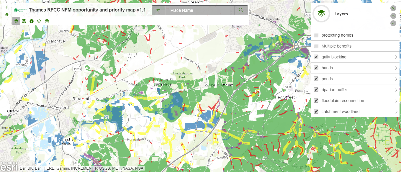
Figure 1: NFM opportunity mapping showing various potential NFM features based on landscape attributes.
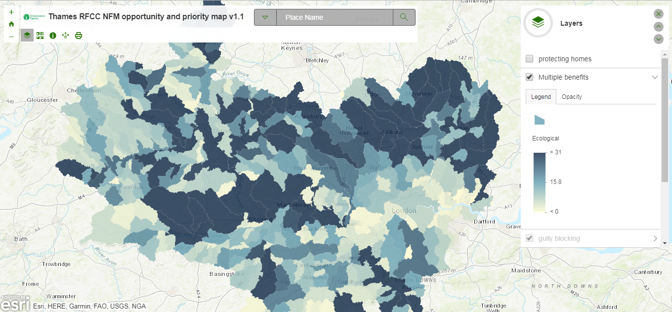
Figure 2: NFM priority map ranking waterbody catchments by the amount of NFM opportunity and what ecosystem services are provided by each NFM feature type that are beneficial to ecology.
Stakeholder quotes
A specially set up Working Group advised that a strategic approach was needed for NFM project development to ensure investment value-for-money. The current Project enables the RFCC to evaluate future proposals for cost-effectiveness and supports LLFAs to develop NFM.
Dr Steven Shuttleworth (Independent Member of Thames RFCC, and Chair of Thames RFCC’s NFM Working Group)
This tool provides the Thames region with a foundation to manage flood risk and water quality holistically. Locally, these opportunities are identified reactively on a piece-meal basis, this tool will save essential time, resource and funding for each organisation in the Thames RFCC area.
Tim Beech (Catchment Partnership Lead, Thames Water Utilities Ltd)
The work from the TRFCC NFM Opportunity Mapping has provided opportunities for PSO to compare and interlace internal priority areas with opportunities for multiple benefits using NFM. The mapping outputs are clear and easy to use, as they provide a visual prompting of potential NFM opportunities which can then be used for further discussion.
Vivian Pham (Technical Advisor, Partnership & Strategic Overview Luton, Hertfordshire & Essex)
Leave a comment